Locating Utilities Under Reinforcement
Ground Penetrating Radar (GPR) can be a great non-invasive investigation tool to determine conduits and pipes running underneath the reinforcement of a concrete slab.
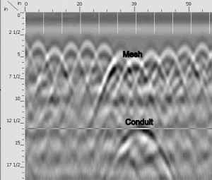
Most ferroscan-type concrete scanners can only give a location of the reinforcement and are largely ineffective when depths get beyond 3-5 inches. Another concern is that they cannot determine the location of a plastic pipe or steel conduits. In the image above, Ground Penetrating Radar (GPR) was used to determine not only the overlapping sheets of mesh (observe the small peaks and hyperboles at roughly the 3-4 inch elevation), but the location of a conduit below the mesh at a depth of approximately 13 inches! (Observe the hyperbole along the 13 inch demarcation line.)
Utility Survey has the latest high frequency/high resolution Ground Penetrating Radar systems to locate these conduits and pipes. And perhaps, save some costly damage and repairs in the future.
To accomplish this locate a Technician must have high resolution GPR systems of a range from1.0 GHz to 2.6GHz; the highest in the industry! How do these systems work? Download our GPR Systems Report to find out.
As Always, Call US Before you Dig!