
“Why can’t ground penetrating radar find everything??!!”
That was the question our technician was suddenly cornered with. He had just pulled up to the job and the client did a walkthrough of a relatively small area; maybe 50 ft. by 50 ft. This client then expressed that he had other places to be but felt obligated to stay on site with our technician, because, after all, this should just take an hour or so, he thought.
Our technician then began to explain our company’s procedure and how we use Radio Frequency pipe locators to supplement the locate process with the Ground Penetrating Radar (GPR) which makes the total time hard to predict...etc., and that’s when the exasperated aforementioned quote came bursting from our client’s lips.
Well, why can’t GPR find everything? It’s actually an excellent question. For a utility locator there are two main reasons that GPR can be inhibited when scanning an area; one is conductive soils and the second is the dielectric constant.
What are conductive soils?
One example of a conductive soil would be clay. Clay has a large amount of ferric material in it, hence clay is considered a conductive soil type. Due to the soil’s conductive nature, the GPR wave gets “scattered” before it can return to the antenna. Other examples of conductive soils would be damp or wet soils that have a high salt content; often near sources of salt or brackish water. The ions from the salts create a much more conductive soil and limits the GPR wave’s resolution.
What is a dielectric constant?
A simple explanation would be that the dielectric constant is a measure of how permissive the soil and the targets in the soil are to the radar wave being pulsed into the ground. It is much more complicated than that, but to not over complicate, we will work with this explanation. So if you have a sandy-mixed soil with a concrete pipe and a metal pipe in it, the GPR wave will enter the soil at a certain rate and that rate will change as it goes through differing soil layers or differing pipe structures. A metal pipe is 100% reflective so it will stand out in the image. Most utilities will actually be noticeable in a sandier soil because the radar wave meets little resistance in this soil until it hits the utilities. However, an old concrete pipe or structure may have a dielectric constant that is close to the surrounding soil. The result is that pipe or structure may fade into the background of the GPR image; making it hard to see.
Highly conductive soils and similar dielectric constants are two factors that can give a GPR technician a difficult time in locating everything that may be in the ground. While GPR is a great piece of technology that we use, a comprehensive underground utility locating strategy involves more that relying solely on one piece of equipment. This is the best protection for any contractor looking to excavate their next construction site with piece of mind.
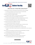
Utility Survey Corp. utilizes a proprietary 10-Step Utility Locating Protocol™" that guarantees a comprehensive utility locate and minimizes misses while promoting success.
Find out more here.
Copyright Utility Survey Corp. 2015 All rights reserved.