Electrical resistivity imaging (ERI) is a non-destructive method for subsurface investigations. Although it’s not as popular as ground penetrating radar (GPR), it has its advantages and can be very useful in some situations.
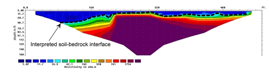
ERI involves the measurement of the apparent electrical resistivity of subsurface materials. During an ERI survey, the electrical current is injected into the earth through a pair of current electrodes, and the potential difference is measured between a pair of potential electrodes. The current and potential electrodes are generally arranged in a linear array. The apparent resistivity is the bulk average resistivity of all subsurface materials influencing the flow of current. A typical ERI survey involves multiple such measurements of apparent resistivity with various configurations of electrode locations. The data is then processed and resistivity contour maps are produced to show resistivity variations along depth and horizontal positions. Since the electrical resistivity of subsurface materials varies with their compositions and water contents, the resistivity contour maps can be used to get a general background of the subsurface condition or find interested targets. For example, since soils and bedrocks generally have different resistivities, ERI can be used to delineate soil-bedrock interfaces.
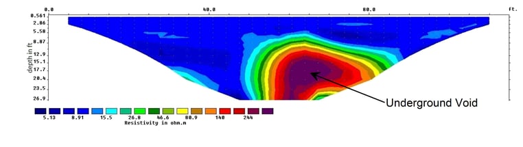
Just like GPR, ERI can produce 2D or 3D subsurface images. The difference is that, compared to GPR, ERI provides images with lower resolutions but deeper investigation depths. In one hand, the minimal sizes of targets are typically in feet instead of inches; in the other hand, its investigation depth can easily reach 50 feet or more. Applications of ERI include but not limited to:
- Sinkhole/void locating
- Mapping of depth to bedrock
- Groundwater table investigation
- Mapping of bedrock fracture zones
- Mapping extents of conductive contaminant plumes
- Landfill delineation
- Archaeological site mapping
Contact Utility Survey Corp today to learn more about our Geophysical Services!